


Aqua Map New Zealand app for iPhone and iPad
Developer: GEC s.r.l.
First release : 19 Dec 2014
App size: 82.56 Mb
An app to satisfy all your Fishing and Boatings needs, developed with the help of professional fishermen. You will download the best nautical charts and enjoy your new fishing season. Press the RECORD button, put the phone in your pocket and record your fishing trolling track....and much more.
►► Features:
• Optimised for both iPhone and iPad use.
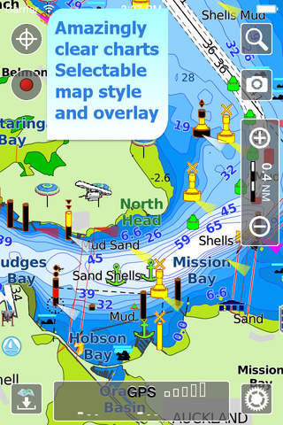
• Amazingly clear marine maps, thanks to the Retina map display.
• Only Official nautical charts from LINZ Hydrographic Office.
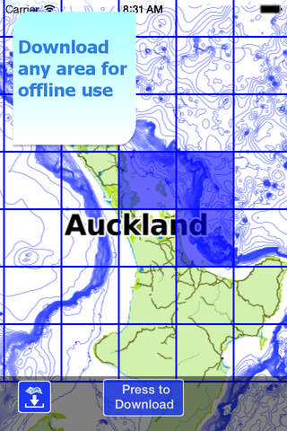
• You can download the maps on the device, to be used later without any internet connection.
• Plan and navigate your ROUTE
• *** NEW *** Expand your horizons with mapXpan (patent pending).
• Easy to use.
• Optimized battery usage with battery consumption monitoring.
• Share tracks, markers, routes and pictures in various formats (KMZ and GPX).
• Customize your Markers icon and Tracks and Routes color.
• Add the Satellite images as overlay of your maps.
• Measure distances on the map.
• Load any track, marker and route from internet communities (KMZ, KML, GPX also if zipped)
• Query map objects with your finger tip
• Search map objects around you or search places by name worldwide
*** NEW ***
► mapXpan
This new mode will greatly extend your display; you will have the details you need for a safe navigation seamlessly integrated with a large overview area. Using this new mode you will see a map 64 times larger than the standard mode without losing any detail in the center part of the screen.
► MAPS
Aqua Map lets you download the best Nautical charts (from LINZ) with depth contours, buoys, lights, etc. and all it is necessary to enjoy your best marine experience. You can download the maps at home within your device and then use them on the boat without any Internet connection. Check our Nautical charts at: http://www.globalaquamaps.com/AquaMArine.html#NewZealand
► SHARING
Why do not sharing your favorites markers on Facebook or sending an email with your last daily track, with all the pictures you captured to show them on a PC ? With Aqua Map it is just a click.
► ROUTES and WAYPOINTS
Plan your trip, insert and edit waypoints. Navigate your route and monitor distance, time and direction toward your next waypoint.
► LOADING OTHERs TRACKS AND MARKERS
Aqua Map can load any KML, KMZ, GPX (also zipped) you can find over the internet or received from your friends. You can load tracks and markers generated from any application (e.g. Google EarthTM, Maps, or other iPhone/iPad apps), obviously including Aqua Map, or any device (e.g. Garmin, Nuvi, Magellan, etc.).
► OPTIMIZED BATTERY USAGE
Unlike many other apps, Aqua Map is designed to use at the best the battery power. Its Battery Consumption Monitoring will stop the track recording when the battery is too low, in order to ensure the phone is still usable at the end of your navigation.
► iOS BACKGROUND MODE
Aqua Map works also when in background, you can receive/make calls and messages while the track recording is running.
► TYPE OF PURCHASES
- Unlimited: you can download and update your charts forever.
- Subscription: it is an year auto-renewable subscription, which means that once purchased it will be auto-renewed every year until you cancel it 24 hours prior to the end of the current period.
Terms of Service: http://www.globalaquamaps.com/Acknowledge.html
Privacy Policy: http://www.gec-it.com/GEC-privacy.pdf
————
Like any GPS, the signal quality can vary very much depending by the amount of visible sky, foliage, weather condition, etc. GPS is not reliable indoor.
The continuous GPS usage, also in background, can drastically reduce the battery life.